The second refuge that I am stationed at as a Wilderness Fellow is the Monomoy National Wildlife Refuge. It is at the end of the elbow of Cape Cod, MA and consists of North and South Monomoy islands. These islands have converged into a long skinny tear drop that extends into the Atlantic Ocean and Nantucket Sound. In 1970 they were designated as wilderness except for two small, carved out portions. Unlike my last refuge where the wilderness was a small piece of the refuge’s land and subject to little of the total management activities, most of Monomoy’s attention involves wilderness lands.
 |
| Banded juvenile Red Knot. Photo: Deb Harrison |
From a biological stand point, Monomoy is for the birds --primarily shore birds although it is also a critical stopover for several migration routes. During this part of the season, piping plovers have fledged, the tern colony disbanded, and Red Knots become the highlight. Red Knots are a medium-sized shorebird with a reddish underside. The American subspecies migrates from sub-Arctic Canada to the Caribbean. The population today has been reduced to one fifth of its previous size, possibly due to habitat disturbance and a decrease in horseshoe crab eggs as a food source. This decline in population size has made research and bird banding more important. For about a week, a small group of biologists and volunteers attempt to band as many Red Knots as possible on the beach.
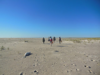
I was able to fill in one of the volunteer spots for the day. We wake up early in order to completely set up before high tide. We fill one boat with equipment and a second boat with people. The boat ride from the mainland is about 15 minutes to the portion of South Monomoy that we must reach. The boats slow through the shallow water until they can go no further then we unload our equipment to the shore. The equipment necessary for a day of bird banding is more than I can faithfully list; it includes nets, cannons to release the nets, more than a dozen collapsible chairs, a fire box, a tool kit, scopes and tripods and, of course, snacks. We fill our two carts to the brim and carry what’s left. We walk maybe a quarter of a mile through a variation of mudflats, gravel and soft sand when we reach posts with triangular signs. It’s the refuge boundary; past this point we can no longer use our carts.
 |
| Walking with our equipment. Photo: Deb Harrison |
At the outset of the day, the lead biologist explained that we were entering a wilderness area where mechanical transport is prohibited. She said how even if we think using the carts just this once will have no impact it begins a slippery slope in which anything becomes a reasonable excuse to violate the Wilderness Act. I nod along knowledgably. If anyone, it is my role to be the wilderness ambassador.
That was before I learned how much equipment I had to carry for what seemed like a mile, if not more. I’m sure other wilderness fellows and recreationalists would say that hiking a mile in X or Y wilderness is really tough –mountains or subzero temperatures or boggy swamps. I am in no position to say that this walk was tougher, but soft sand works all sorts of mysterious calf muscles, the sun is ablaze and sometimes you’re downwind of a seal carcass. I made this walk six times. My legs feel fine, but my arm muscles burn and hours later I still had three dashes on each of my forearms from the metal bars of the chairs I held. Reaching those carts at the end of the day for that last quarter mile was fantastic.
 |
| Furling the net. Photo: Deb Harrison |
We set up a net, camouflaging it in the sand, then hide behind the dunes and wait for the Red Knots to arrive. Behind the dunes is our base camp. The shorebirds can’t see us and we can’t see them. A few biologists are stationed with scopes and binoculars. Ever so gently the biologists try to guide the birds to the location in front of the net. It’s called twinkling, which is just funny. It’s amazing how sensitive the flock can be: is that plover in the way? How are the waves falling? Did that peregrine flying overhead just ruin everything? Monitoring the flock lasts for two hours. The biologists tirelessly count birds and give instructions to the twinklers.
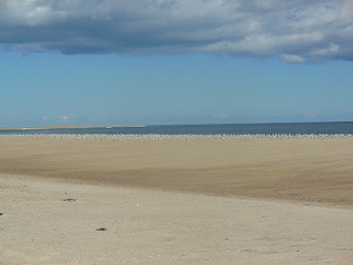
Back at basecamp, I rest against my backpack, gaze at the low line of clouds and frankly doze off to the sound of the biologist's instructions over the radio. I rejuvenate myself with candy corn and await the release of the net. Then we would run over the dune, save any birds from the water, distribute them in holding cages and let the banding begin! However, abruptly, the biologist makes the call not to release the nets but pack up instead. It sums up to too many of the birds that we don’t want and not enough Red Knots. When I finally see over the dune, there are hundreds, if not, thousands of sanderlings, and somewhere in there, maybe a dozen Red Knots.
 |
| Sanderlings on the shore. Photo: Deb Harrison |
It occurs to me while walking back to the boat with the chairs that if any elaborate conspiracy was necessary to get me away for the day, just invite me to join a Red Knot banding project. I will obediently carry the most I can, up and down the beach, then sit behind a dune without even seeing the targeted bird.
The thing is, if they said they needed me to do it again the next day I would have agreed. All the other volunteers were ready for a repeat of the long, tiring, cart-less hike. I think they are on board because they care about the Red Knots (they are now also addicted to finally having a good catch) and they’re willing to do it without the aid of mechanical transport because they believe in wilderness. Why else do people do things the hard way unless they believe in the cause? My arms are sore and as a cruel twist the chairs weren’t necessary because we didn’t have a catch. Still there were moments of complete beauty –seals bobbing in the surf as I walk by, a sweet breeze as I am stretched sleepily in the sand, and the incoming ride with the flat island fringed in beach grass. And we musn't forget this long stretchof land, clear of tire tracks, it is great for the birds. Wilderness designation, while at times challenging to work with, has preserved this beautiful landscape and prime habitat.
Taryn Sudol
Monomoy National Wildlife Refuge
Wilderness Fellow

